- THE PLAN AND THE START
We were eating recently at a restaurant, Valentina, Sammy, and I. During that meal, talk about mountaineering came up. Valentina told me that yes, that she would go with me to climb Mount Shasta. It was a bit of a surprise to me because she had been telling me that she’d do it only after I made at least two backpacking trips like the ones we’re kind of used to.
A person as obsessed with this mountain as I am only needs that someone says «let’s go» to start planning everything right there.
The next day I mentioned this to my friend Alejandro, whom was one of the two people that went with me on my first attempt several years ago. He has tried a few times with me but hasn’t been able to summit it yet; the other person was my son David, with whom I managed to reach the top of this mountain in May of this year.
Well, my friend received this news very positively and told me that he would come with us. At the time, the plan draft was that we would drive on a Friday afternoon after work and start walking that same night. We said we would do it day-hike style, which means you don’t stop to sleep. We also said that the next day, when we returned, we would stay in a hotel in the nearby town to rest, and we would make the trip back home on Sunday.
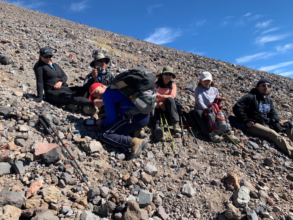
In the following days, the number of people who expressed their interest in this adventure increased. In the end we ended up being a group of 7: Nena, Cristina (Nena’s sister), Melissa (A friend of mine’s daughter), Omar (Melissa’s boyfriend), Alejandro, Valentina, and I.
As the date came close, we were all focused on the logistics: what backpacks to use, what to bring, the weather, and so on. We planned to leave at 4 in the afternoon. My experience in this mountain told me that the trip by car would take about 5 and a half hours plus the time that we used in stops for gas or whatever. I thought it was going to take us about 7 hours in total. That time-frame would put us at the beginning of the hike before midnight.
I had some prescription pills that are used to counteract the negative effects that high altitude in some people. The day before our trip I gave each of them one, with the instruction to take it the next day around noon.
The day arrived and I told them that one of our first stops would be for lunch. Alejandro told me that they already had eaten and that they’d leave half an hour later, since they didn’t need to stop for lunch. His argument made sense from the point of view that it is not very cool to sit down just to watch other people eat. We would split, then: Valentina, Meli, Omar and I, in a car, and Alejo, Nena and Cris in the other.
Anyway, we ended up leaving late, at 4:30. The place where we decided to stop for lunch had tons of cars in the drive-thru, so, we downloaded the app from that restaurant and placed the order from one of our cell phones and waited for our food to be served. We decided to eat there, outdoors, despite how hot it was.
After eating we continued our long journey.
We had more delays because in a couple of stops, one to change drivers, the other one to fill up the gas tank, we took exits that did not have easy re-entry to the highway. This made us spend time looking for entrances farther ahead.
We were in the last little town, which is called McCloud, just after 11 at night. A little further, the dirt road started. It was a cool place to use the Jeep that Valentina got two weeks ago. It was 12 at night when we started on the dirt road.
We did not have any complications in this section. Our next delay was the time we used after we parked our cars to setup and get ready to start the hike. We arrived at the parking lot at 12:37 p.m., but we started the hike itself at 1:30 in the morning.
2. HIKE UP
The first section of this trail is the easiest of all because it isn’t very steep. It’s 3 miles that on the way down feel like they’re 8! In this section I helped Cristina adjust her backpack because although no one was carrying anything heavy, hers was not well adjusted and her lower back was hurting a bit, she said. The end of this section is at the headwaters of a creek that gives this route its name, “Clear Creek”. When we got to that point, at 3:30 in the morning, it had been our plan to stop there to eat and take a break before starting the “serious” part of our hike. On this site I gave them the second pill for AMS (Acute Mountain Sickness). We were there for 25 minutes. How do I know the times? I had my GPS on, and the thing automatically records time and position every so often.
I’d told Valentina that I had a surprise for her and I’d give it when we stopped to rest. It was before crossing the creek that I gave her the surprise: The title of the car she had bought two weeks ago had arrived at the house that day. I carried it with me all this time, just to surprise her.
We started again at almost 4 in the morning, and we quickly reached the first rough climbs. “Rough”, because the ground was sandy and scree, which makes your steps slide back a little. This results in extra effort needed for each step, but we continued. The pace was slow, but it was the most adequate pace for our group.
It took us an hour and a half to cover the next ¾ of a mile. In this time, we gained a thousand feet in height, from the 8400 at the creek to 9400. Here there were some rock formations that Alejo and I knew very well because it was the place where we had camped on our first attempt, seven years before.
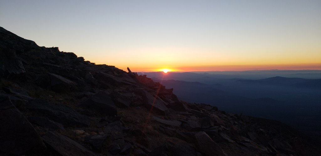
We continued our course, and at 6:14 in the morning we saw the exact moment of daybreak. Obviously, we stopped to watch that whole show until the sun came out completely on the horizon. We continued our hike.
A little higher up, it became clear to us that Omar was feeling pain in his hip. Valentina had given him an icy-hot cream that is used for similar things, and Omar used a little. Apparently, it did not do much for him, because later he continued expressing his discomfort to Melissa. I heard and told him to give me his backpack to see if walking without a pack would ease the pain. It seems that it did help him a little, but it did not completely solve the issue. A little higher up I heard when Cristina told him to take it easy and to walk more slowly, if necessary, because she didn’t believe that one of those injuries would disappear with more hiking, but it could worsen. I asked Alejandro to stop (he was hiking ahead of all of us), that I needed to talk to everyone. I was hiking at my usual position, the last one, to make sure that no one was left behind.
When I was close to everyone, I told them that we had a situation: Omar was walking with the start of an injury. I saw two options: One, that he took an anti-inflammatory pill like ibuprofen, and continue to keep an eye on his pain, and the other option was that he simply waited for us some place that we found, where he could wait. I also said that I was not anyone’s boss, and that I was saying what I was saying because it was a reality that was in front of us that we needed to deal with. Almost immediately, Omar said that he wanted the pill and that he understood my concern. Luckily, Nena was carrying strong ibuprofen with her. Omar took one, and we continued our ascent.
3. MUSHROOM ROCK
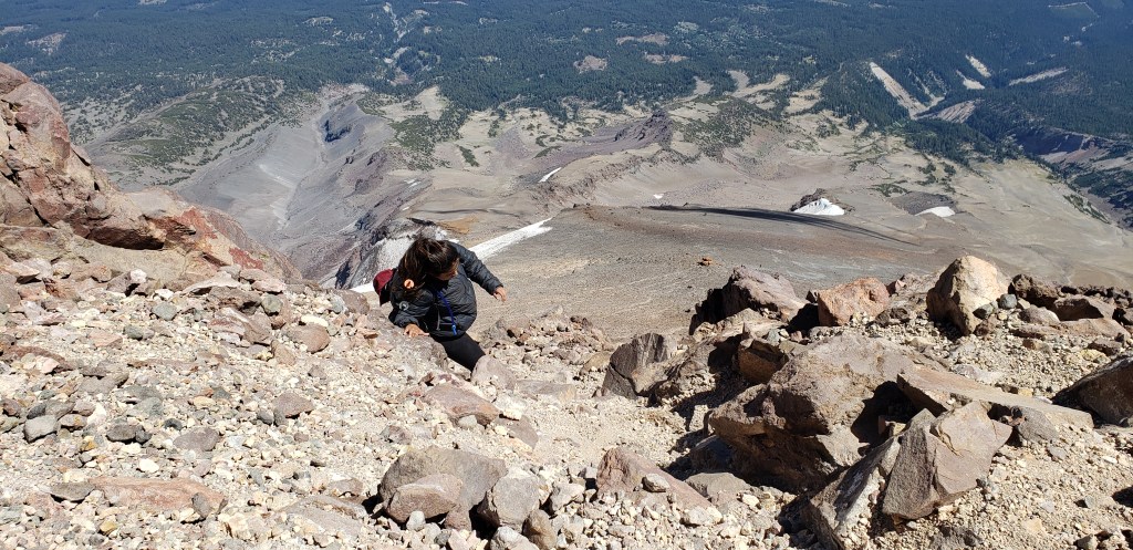
A little earlier, I had seen far away, what would be our next target: a rock formation people call «UFO rock», or «Mushroom rock». When we finally reached this rock, it was the exclamation point of what we had covered, distance-wise. I was very, very tired when we got to that rock.
From that spot, it isn’t super clear which way to go because there’s a rock wall right in front that looks difficult to climb. I seemed to remember that, towards the right it was supposed to be much easier.
While we were resting, and I was looking and thinking which way we had to go, the first blow fell to our adventure: Melissa, the daughter of my great friend Pulga said that she wasn’t feeling well at all. She said that she felt that she wouldn’t be able to continue. Her momentary decision was to stay at that point and wait whatever hours were needed for us to return from the summit. Her boyfriend, Omar, logically said that he was staying with her. Of course, the girl was not going to be left alone under absolutely no circumstances, even if it meant that the whole thing needed to be aborted. They said that they would start the descent very slowly and that we would eventually meet again when we came down later. The other people in the group accepted this decision from them, and we maintained the intention of summiting.
We said goodbye to the two of them and continued, but not to the right, which I thought might be the best option, but to the left because a woman, who was one of the people who were returning from the top, told us that it was easier to skirt the stone wall ahead of us towards the left, even though that would add like 3 hours to the hike. We listened to her and the 5 of us who were left began to walk in that direction.
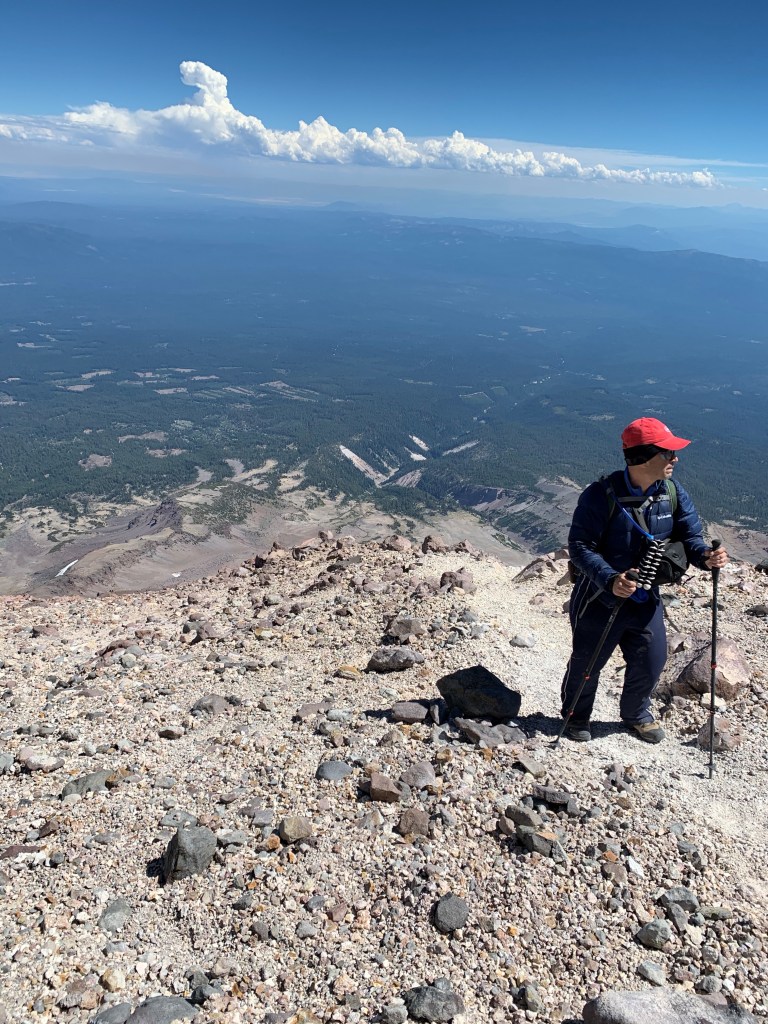
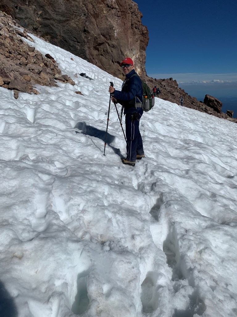
It was very windy and very cold. Fortunately, we were all adequately protected for this weather. A small cloud passed. Then another. This mountain stands alone, it isn’t connected to any other and is relatively high (14,179 feet / 4,322 meters). These conditions make mountains like this generate their own «micro-climate» on their tops. In Shasta, it isn’t rare for its top to suddenly get cloudy and get thunderstorms. This is the main reason why it is recommended that a return time is set, and that it’s no later than noon. However, the weather of our day was more than spectacular.
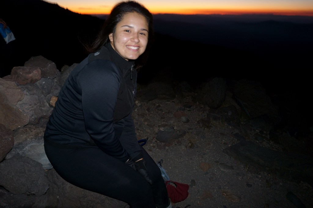
I think that the combination of risk factors (clouds, time, daytime left, how difficult the climb of those stones looked), made Nena give up. I think an «external» factor that made that decision easier for her was the fact that Meli and Omar had not long ago started their descent. She closed the door to any attempt of mine to convince her to continue. Alejandro said that he would go with her. Nena tried to convince him that no, that he should/could continue, that nothing bad was going to happen to her because the other two weren’t very far. In fact, we could still see them. Cristina said that she did not feel safe to continue either and that she preferred to turn back with her sister. I listened and understood that there wasn’t much I could do to convince them to continue. I was very unsettled to see myself at this height and think that I would not make the last push to reach the top. However, since I’d already been at this summit four times, it wasn’t too hard to digest that apparently, we would return from that point. I felt mentally exhausted, as far as convincing people is concerned, when suddenly my daughter told me «Pa, if you want to continue, I’ll continue with you.»
Initially I thought I had misheard, but my girl repeated what she had said. The other three gave voices of encouragement, and I tried not to overstate my joy at what Valen had said.
We hugged and said goodbye. Fortunately, their car had room for two more people, exactly what we needed. We agreed that we would meet at a hotel when we returned. They began their return, and we made our attack on that wall in front of us.
Funny how the brain sometimes works. When I reached the «mushroom rock » I was dead tired, but hearing Valentina say «Pa, let’s do it», made my brain shoot a bunch of adrenaline to my body. Suddenly I felt whole, with energy for whatever.
It so happened that we ran into some people who were coming back from the wall, who told us not to do what the woman had recommended before; that the best thing was that we followed a path that was close and was easily visible from where we were; that although it looked difficult, in reality it was not that much. We listened to the guy. It is my experience that the social aspect among mountaineers is one of the best that exists.
4. THE WALL AND THE TOP
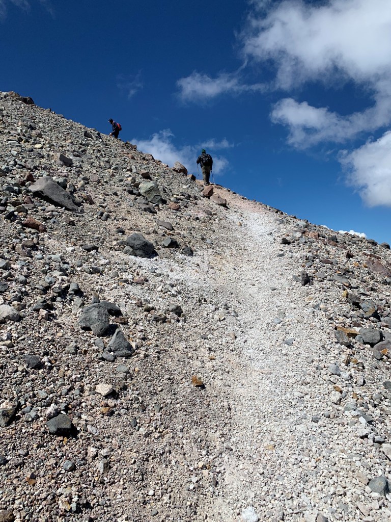
And we attacked the wall. At the beginning it was more or less a normal path, a little steeper but in a way that the hiking poles were still useful. Eventually we got to the first place where it was necessary to use our hands to hold ourselves while we took the next step. Sometimes we could do that without having to put the poles away by letting them hang from our wrists. At one point they got in the way, so we put them on the packs, which had convenient straps to do this.
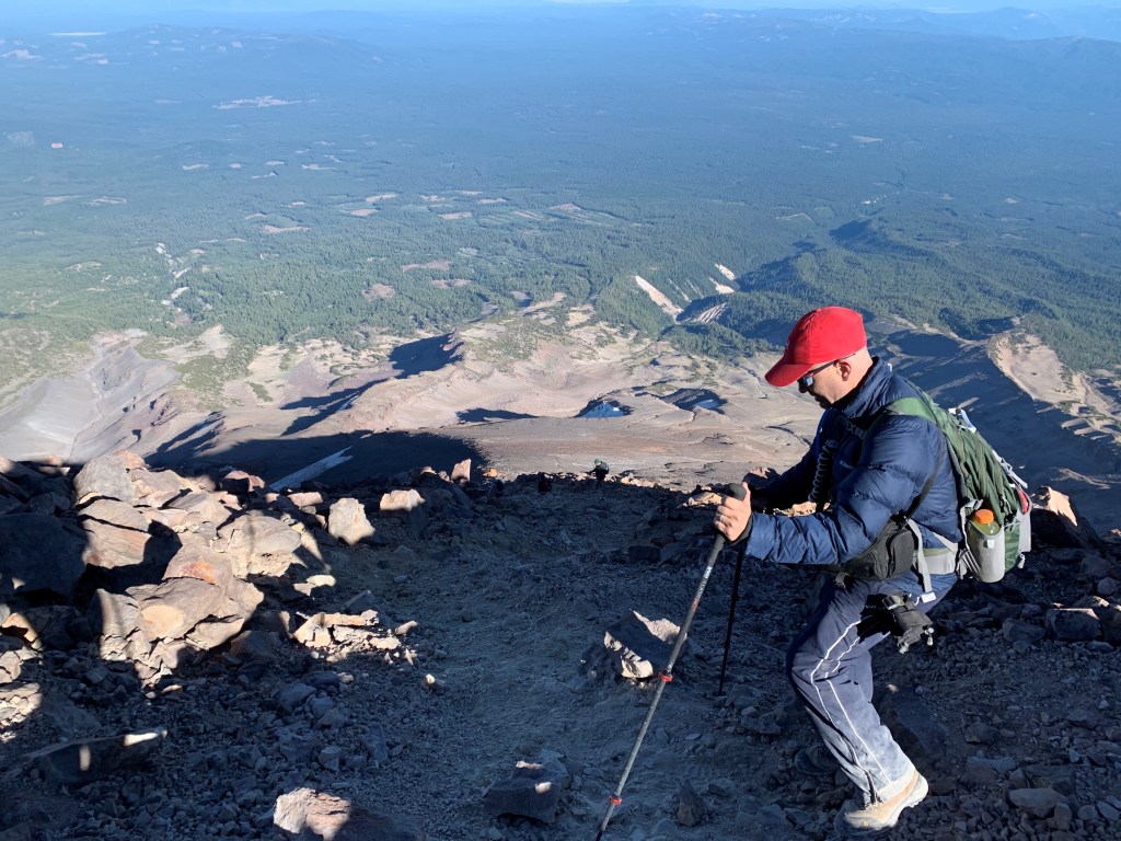
We continued this climb on the rocks. The weather was still good. The clouds did not return. It took us a little over an hour to reach the top of this wall. We were able to shoot two small video clips, one of each of us climbing this section. At the top of that wall, what follows is a short section that’s almost flat and connects to a small hill that sucks because it is a bit steep. This is already at 13,530 feet. Remember, this mountain is 14,179; in other words, at this point we had less than a thousand feet of height to climb, which doesn’t translate in the same distance to hike.
We had crossed paths with a couple of mountaineers climbing the wall. In the «flat» part that followed, it became clear that they did not know where they should go to get to the summit. What happens is that up there you can see something close, but on the opposite side, which looks like the top. I assured them that no, that that wasn’t it, that we had the top right in front of us and that it was now only a matter of finding the best route to get to it. It was funny that we heard other people who had climbed before us, on the fake summit. It must be terrible to make all this effort and then realize that no, it was close, but it was not the right summit.
We got to the top of the little hill that followed and we saw that what came next was another section of stones, hugging the mound where the real summit was. No problem. One step at a time.
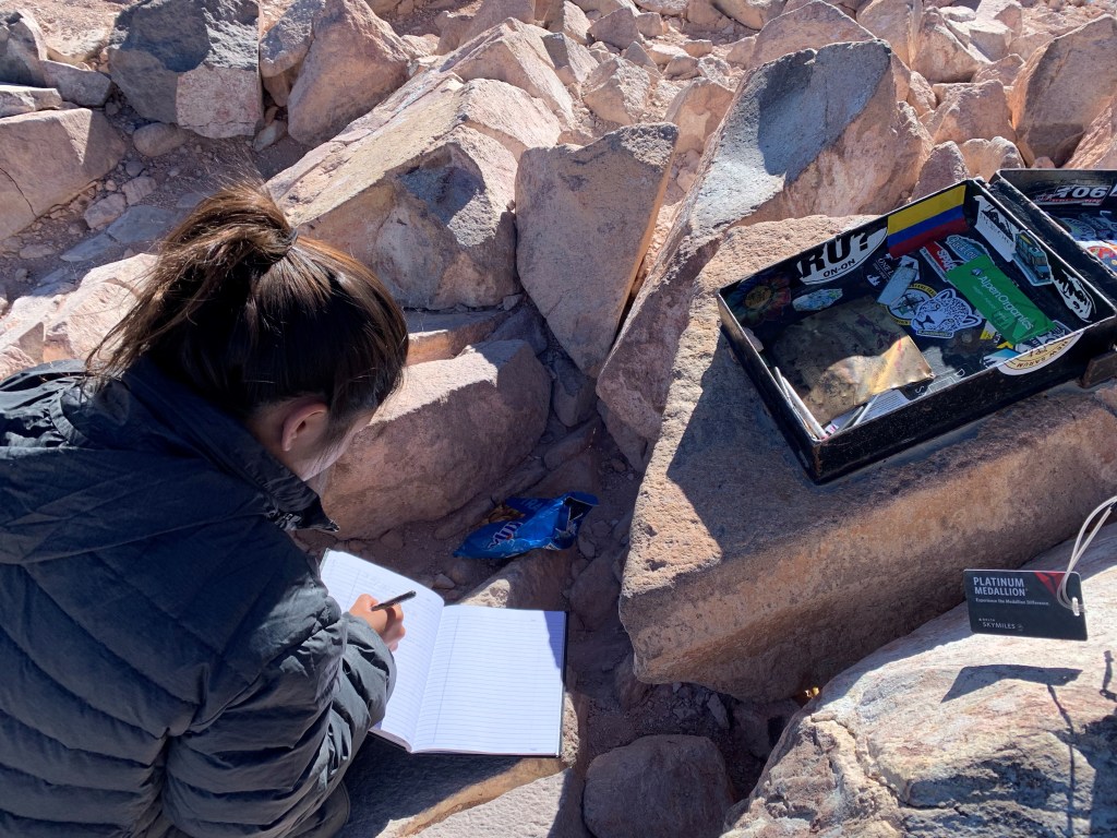
We found another person who was going back, to whom we asked the routine questions: How long to the top? Which is the best way? I also asked him if he had signed the logbook on the summit. He answered me asking if that wasn’t a joke; He said that he had heard about the book but that since he did not see it, he thought it must have been a joke. I assured him that it was not a joke; that I had not only signed it four times but had also put a sticker of my country’s flag in the box where the book is. I also told him that he should come back with us, that the summit was close and that it would take him at most an hour to do that.
The guy followed my advise, and went back to look for the book. We continued our ascent between those rocks, slowly and being careful. The other guys had long passed us, and we could already hear them up there.
This climb to the summit was not what I remembered, and at one point I felt disoriented. It was very good that the other guys were already there. As soon as I could see one of them up there, I asked him to guide me, which he did very well. A couple more minutes and Valentina and I made it to the top of Mount Shasta!
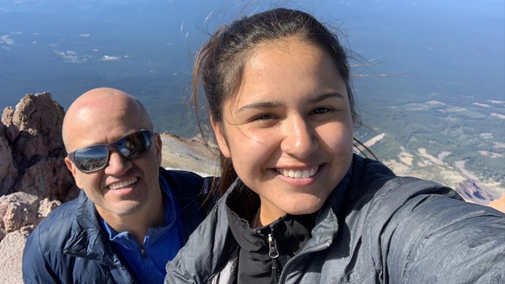
It was 3:40 when we reached the top. I don’t know how much time we used for photos and signing the book. I was eager for us to start our return as soon as possible, to make the most of the daylight we had left. I saw the daylight as absolutely necessary to see our descent down the rock wall and find the way down the ‘mushroom’ rock.
It is worth mentioning that, despite it not having been the reason for us to summit this time, I really wanted a photo on that spot with my daughter because I have one with my son, which I consider the best photo I have of all my trips to mountains, from a photographic point of view. So, what I wanted was to repeat the same composition. That took some time, the photo setup. When I was happy with what I was seeing on the camera, I asked one of the other 3 people that were at the summit with us to take the photo. I stood next to Valentina, and the guy took 6 very good photos of us. Then I went and took some that she wanted of her alone, and then she did the same for me.
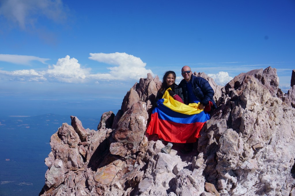
The signing of the book was also something special, writing my note and my name below my daughter’s. It was also very cool to see the Colombian flag that I had made years ago still attached to the box where the signature book is.
5. THE BEGINNING OF THE DESCENT
Well, when we finished our entire process at the top, we started our descent. It was approximately 4:45 in the afternoon. The 3 guys we had seen above were very close ahead of us. There was a fourth guy who happened to be the last one to reach the top that day. It was pure coincidence that those people were from the same state, Minnesota. In American football, the team my daughter (and my entire family) likes is the New Orleans Saints. One of the teams that the Santidoom like least is the Minnesota team, the Vikings. At the top they joked about this with Valentina, but in a very jovial and friendly way.
Anyway, we continued our descent. They were ahead of us, close. My wish was not to lose sight of them and use that as a guide. This worked very well. Climbing down the rock wall section was not very difficult, but at one point Valen slipped in one step she took but was able to stop. This was near the end of the rock wall. What followed was a relatively short distance, kind of flat, to the ‘mushroom’ rock.
When we got to that rock, Valen gave me some shocking news: She believed that she had injured her right Achilles tendon; that she didn’t fill well taking a step, that she was going to rest a few minutes to see if the it would go away.
My mind started bursting: What if we continue but it hurts more farther down? What if we stay here and I call the ranger? Then what? Will they send a copter to throw us a tent? The biggest problem was that: It was getting dark and we had no protection for the coming weather. I thought the only thing we could do would be to get under the ‘mushroom’ rock, but we didn’t really have gear to protect ourselves from the freezing temps of the night at that height. I was seeing a situation that could get very critical. Valentina started walking and told me that she felt she could continue. I didn’t express any of my panic to her so she wouldn’t worry more, but I kept walking by her side, keeping an eye on every step she took. I looked at my watch. We had almost two hours of daylight left, which was phenomenal. The path was very clear and what made it difficult to walk up (scree and sand) was something to our advantage going down, because each step slid a little further, effortlessly.
